
The climate of Peru is diverse with three major regions (micro-climates) making up the South American country; the coast, the mountain range, and the jungle. This article aims to identify the key characteristics of the Peruvian climate and preservation techniques for the Amazon rainforest. Peru has a land area of 1,279,999 square kilometers. This article will explain Peru’s climate with a brief emphasis on geography.
The Coast
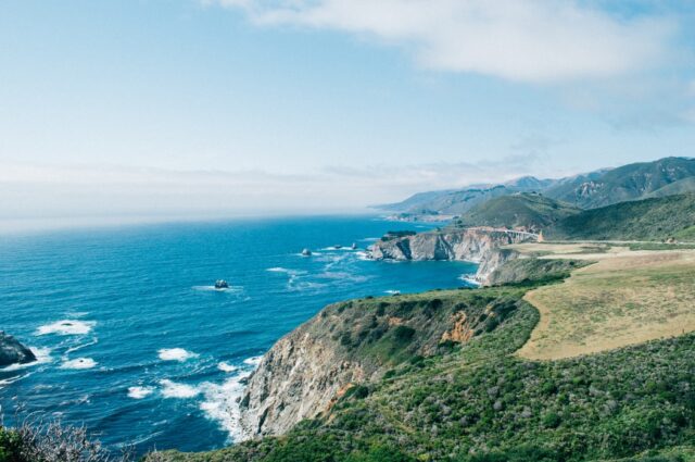
The Peruvian coast is a long desert strip that stretches from the north near Ecuador to Chile near the South. Its total length is approximately 2500 kilometers. The coast of Peru borders the Pacific Ocean, and while it is near the equator and a desert climate, it does not receive large amounts of sunshine. Perhaps the desert classification is attributed to the fact that the land is very arid or semi-arid meaning that it does not receive much rainfall.
The cold Humboldt Current blocks most of the precipitation from reaching coastal Peru. If this current was warm, then it would end up in large scale orographic rainfall. Orographic rainfall is a type of precipitation that is created by a forced upward movement of air when it meets a physiographic upland such as a mountain range. Further to that, the Humboldt Current works by preventing the formation of rain clouds by not allowing vertical air current to build.
And while precipitation is low in the Peruvian Pacific north coast, the precipitation that gets blocked off does buildup in anticipation of El Niño which may result in significant flooding.
The central and southern coast experience temperature ranges from 8 degrees to 30 degrees Celsius with an arid climate where rainfall is rarely seen crossing the 150 mm level. The summer brings humid and sunny conditions where temperatures fall between 20 to 29 degrees Celsius. Near the Ica Desert, the temperatures may reach extreme heat which can reach 35 degrees Celsius. The Andean convection may cause short-term rainfall during the summer that grosses minimal 10 mm levels, but this usually takes place at night.
During the winter the central and southern coast experience cool but damp conditions with most of the region’s precipitation occurring during this time.
The coastal waters also hold a large amount of marine wildlife including anchovies, crustaceans, flounder, sea bass, shark shellfish, sperm whales, and tuna.
As you proceed further inland from the coast, you will notice a garua which is a layer of fog exclusive to Peru and Chile. The Humboldt Current in part contributes to the foggy atmosphere because the cold air contacts the soil. During this time, the fog-laden vegetation gets a chance to grow on the hills of the coastal mountain ranges and are referred to as Lomas. The lowest the temperature drops in the central and southern Peruvian coast is around 14 degrees Celsius, so it’s still warm.
The coastal climate like the rest of the climate of Peru is transitional. It begins as arid, desert, hot then moves to arid, desert, cold. If we use the Koppen Geiger climate classification map for Peru, we would realize that 15 total categories fit the climate type of the country.
Another major factor that contributes to the climate of Peru is the Walker circulation. The Walker circulation is a type of air movement phenomenon that crosses the Pacific Ocean basin. It works through convective storm systems that push cold, dry air to the eastern Pacific inlands. It also affects Australia as the circulation system there falls on the west coast and transitions over to the east when the seasons change.
The Andes Mountain Range
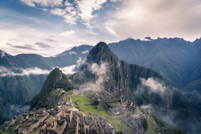
In the Andean highlands, the temperature changes with altitude. The Andean or Andes mountains are apart of a large mountain range that extends from the top to the bottom of the South American coast.
The temperatures in the Andean highlands is warmest at the low-lying valleys and reaches just below freezing point in the highest of elevations. Some of the highest points of elevation include the Huascaran (6770 meters), Yerupaja (6620 meters), and Coropuna (6425 meters). Snow begins to surface on the mountain slopes once you reach the 5000-meter mark.
In the Andean Plateau which is also called the Altiplano, several modern cities exist. Puno is the major city that lies in the Peruvian-Andean Plateau which extends 3750 meters into the air. The Altiplano on the northeastern slope has higher humidity than the southwestern area. Instead, the southwestern slope has a series of salares or salt flats that are the result of its arid landscape. Near the border where Peru crosses into Bolivia, Lake Titicaca is present which is the largest lake in all South America.
Endorheism is the name that is attributed to the inland drainage occupying the central Andes as the Altiplano. It has been compared to the Tibetan Plateau in many ways. For example, its elevation is in close proximity. However, the Altiplano is home to a volcanic zone that has massive volcanoes such as the Ampato and Tutupaca, both of which are in Peru.
One of the driest places on earth lies in the southwest area of the Altiplano which is known as the Atacama Desert and to the east is the humid Amazon rainforest.
Also, did you know that the Andes is the youngest mountain range that was formed only 70 million years ago? The Andes formed as a result of tectonic activity where the Nazca plate slid underneath the continental plate of South America. In fact, the Peruvian Andes has the largest number of snow-capped glacier mountains in the region. Snow beings to appear at elevations of 5,500 meters.
Rainfall in the Andes varies between 200 and 1500 millimeters per year. The rainfall season begins in October and stretches throughout April. The western slopes have a semi-arid climate and only receive rainfall from January to March. Depending on the elevation, the temperature varies between 5 degrees and 25 degrees Celsius.
In the Puna ecoregion the temperatures range from -10 degrees to 8 degrees Celsius during the night and 15 degrees Celsius during the day. The Puna grassland is a biome of shrublands and montane grasslands. It is home to a diverse ecosystem which includes a range of flora and fauna. It is found at an elevation of 3200-3500 meters. The Puna is regarded as one of the eight natural regions in Peru.
Overall, the max temperature in the Peruvian Andes highlands is generally stable, but the low-end may fluctuate. This is mainly due to the presence of clouds which does help preserve some of the daytime heat during the night. However, during May through August, the region experiences strong solar irradiance, dry conditions, and very cold nights. While this is the opposite effect of what solar irradiance is supposed to impose, the coast climate is affected by several factors such as cold wind currents.
As you proceed further east from the Andes, rainfall significantly increases due to its proximity to the Amazon rainforest. However, a lot of rainfall still pours over the mountain ranges as opposed to the low-lying valleys because the precipitation occurs in the form of afternoon convective storms.
Certain cities in Peru such as Cajamarca and Piura have Páramo climates because they are based in the northern aspect of the Andes mountain range.
The Amazon Rainforest
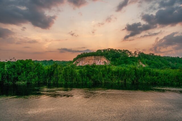
As you approach the eastern lowlands of the Peruvian Andes, you will begin to reach the Amazon Rainforest. The Amazon rainforest is shared among multiple countries including Brazil, Peru, Colombia, and minor amounts in Ecuador, Bolivia, and other nations.
The Amazon rainforest is the world’s largest. Half of the world’s rainforests are present in the Amazon in South America. Sometimes this rainforest is called the Amazon Jungle or exclusively in Peru; the Peruvian Amazonia. There are close to 390 billion trees that come from 16,000 species. In fact, the Amazon rainforest covers 60 percent of Peru’s land area. However, only 5 percent of the population lives in the Peruvian Amazonia region.
The Peruvian Amazonia is divided into two subregions based on the ecology and climate (ecoregions). This is further classified based on elevation with the lowland jungle making up the bottom portion and the highland jungle making up the upper portion.
The lowland jungle is about 80 to 1000 meters above sea level and has a very warm temperature with the median being 28 degrees Celsius. Because it is a rainforest, there is a lot of humidity (over 70%), and the annual precipitation is 2600 mm.
The soils are very diverse with the only major similarity being that they are derived from the river basins. Some of the soils in the area have been subject to improper use in terms of salt deposits affecting soil fertility. The Amazonian dark earth is an artificial soil that is used in the Amazon Basin. Its official name is terra preta which translates to black soil. It is widely used in the Peruvian Amazonia agriculture, especially in the eastern foothills of the Andes. It was made by mixing charcoal, pottery pieces, compost, manure, and pieces of bone to what otherwise is considered an unfertile Amazonian soil.
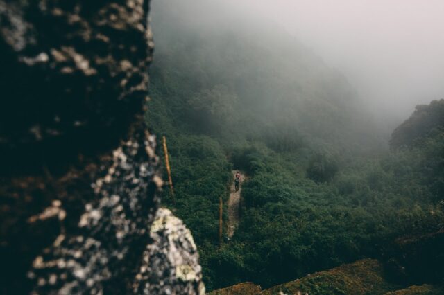
The highland jungle is often referred to as the Andean jungle and sits on the eastern foothills of the Andes mountain range. The elevation of the land rests at 1001 and 3800 meters above sea level. The lower end of the highlands boast warmer temperatures, but it becomes cooler as elevation increases. Most of the fauna in the area is endemic because the difficult terrain does not allow animals to migrate to other locations as easily.
There are also many rivers that run through the Peruvian Amazonia. They are the Amazon, Apurimac, Huallaga, Madre de Dios, Mantaro, Manu, Maranon, Napo, Pastaza, Purus, Putumayo, Tigre, Ucayali, Urubamba, and Yavari.
They are also many variations in flora and fauna in the rainforest, and it is actually the most biodiverse on the planet. There are thousands of species of amphibians, birds, flowering plants, ferns, mammals, butterflies, fish, and reptiles within the forest.
Some of the primary cities located in the Peruvian Amazonia include
- Bagua
- Iquitos
- Jaen
- Moyobamba
- Pucallpa
- Puerto Maldonado
- Rioja
- Tarapoto
- Yurimaguas
The Amazon Rainforest has been subject to many illegal activities that have harmed the ecosystem. For example, illegal logging, oil extraction, and gold mining are practices that have brought significant damage to the biological health of the Peruvian Amazonia. In the section below, we explore this topic in detail and suggest some solutions to how this issue can be resolved.
Preserving the Rainforest
Over the last few decades, illegal logging has risen to become a major issue Peruvian Amazon jungle. By World Bank estimates, it is known that close to four-fifths of the total timber exports in Peru are harvested illegally. While the Peruvian government initiated a system of non-transferable contracts to support small-scale logging activities for local farmers, larger logging companies began buying out the contracts from the local farmers which led to the emergence of a large-scale logging industry.
Another solution that was imposed to prevent agricultural abuse and to protect the Amazonia rainforest was to create a task force assigned as the National Institute of Natural Resources which although part of the agriculture department was intended to safeguard environmental interests. However, INRENA was largely unsuccessful in completing its objective primarily due to the lack of enforcement resources in the country and in part due to the corruption of the system. Some of the exploitation is in part due to the laws of neighboring countries such as Brazil. For example, in 2001 Brazil mandated a law that would prohibit the exports of Mahogany wood from the country. As a result, much of the focus was applied to the Peruvian Mahogany wood and logging activities increased there.
The Environmental Investigation Agency which is a UK based non-governmental organization states that the largest contributing factor in the illegal logging industry is the easy permit access granted by the Peruvian government. These permits allow the exportation of illegal wood in conjunction with legal goods out of the country. There are also only a handful of logging roads within the Peruvian logging industry, so it is not a matter of where to look. Controlling the movement of shipments and stopping the illegal ones is one way to do it but perhaps it does not provide an economic benefit which is why this method is neglected. Instead, it is wise to replant the trees because wood is a renewable resource, it simply takes nature time to replenish the trees.
In 2007, the United States and Peru established a Free Trade Agreement that came into implementation in 2009. Within the agreement, the U.S.A requested a binding commitment for Peru to improve the environmental protection factors in its forestry sector. This has led to improvement between the two countries as only 35% of timber exports contain illegal wood versus the international average of 80%.
There is also the issue of illegal gold mining in the Madre de Dios Region which has proven to be extremely harmful to the ecosystem. In fact, mercury imports increased as a result of the lure of gold mining in Peru to support mining. The mercury is not used in accordance with the correct technology and finds its way into the atmosphere and pollutes the water streams.
Oil extraction is another activity that has not been performed in a sustainable manner to preserve the natural environment of Peru. There is estimated to be a lot of oil in the Amazon rainforest, but it is a threat to the indigenous people living there especially with the Camisea Gas Project. In fact, 730,000 square kilometers have been allocated to the oil drilling project. Access roads for oil and gas extraction lead to use by illegal miner and loggers. To date, only 10 percent of oil exploration blocks have been extracted which paves the way for further ecological damage as the rest of the blocks are found, and oil is taken out from under the ground. Overall, while it is important to protect the economic benefits associated with exporting a country’s natural resources, it is also important to maintain the ecosystem for future generations so that the entire process is sustainable and renewable.
Another solution that has been enacted is the biological stations formed by the Amazon Conservation Association. The mission of these biological stations is to monitor and protect the diverse landscapes of the Peruvian Amazonia. They work with the public, communal and private zones, and with the government to manage the movement of natural resources. Their approach is based on scientific research and fieldwork in the Amazonian Andes mountain range.
Conclusion
In conclusion, Peru has a diverse and ecologically rich climate and geography. It is home to some of the most endemic species of flora and fauna. However, the economic burden that is placed on the people has led to improper use of the landscape that endangers the fate of the ecosystem. All in all, Peru’s climate consists of the Costa, Sierra, and Amazonia which make it one of the most distinct geographic locations in the world.


